
Berkas:Land shallow topo alpha 2048.png

Ukuran asli (2.048 × 1.024 piksel, ukuran berkas: 1,58 MB, tipe MIME: image/png)
| Deskripsi |
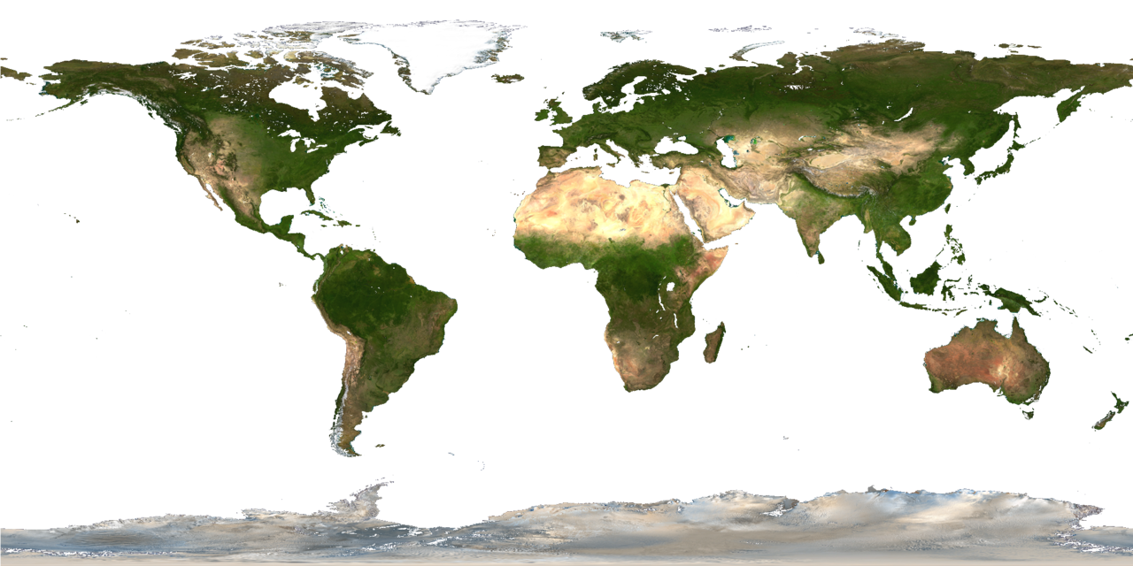
Description from http://visibleearth.nasa.gov/view_rec.php?id=2433 : Credit: NASA Goddard Space Flight Center Image by Reto Stöckli (land surface, shallow water, clouds). Enhancements by Robert Simmon (ocean color, compositing, 3D globes, animation). Data and technical support: MODIS Land Group; MODIS Science Data Support Team; MODIS Atmosphere Group; MODIS Ocean Group Additional data: USGS EROS Data Center (topography); USGS Terrestrial Remote Sensing Flagstaff Field Center (Antarctica); Defense Meteorological Satellite Program (city lights). This spectacular “blue marble” image is the most detailed true-color image of the entire Earth to date. Using a collection of satellite-based observations, scientists and visualizers stitched together months of observations of the land surface, oceans, sea ice, and clouds into a seamless, true-color mosaic of every square kilometer (.386 square mile) of our planet. These images are freely available to educators, scientists, museums, and the public. This record includes preview images and links to full resolution versions up to 21,600 pixels across. Much of the information contained in this image came from a single remote-sensing device-NASA’s Moderate Resolution Imaging Spectroradiometer, or MODIS. Flying over 700 km above the Earth onboard the Terra satellite, MODIS provides an integrated tool for observing a variety of terrestrial, oceanic, and atmospheric features of the Earth. The land and coastal ocean portions of these images are based on surface observations collected from June through September 2001 and combined, or composited, every eight days to compensate for clouds that might block the sensor’s view of the surface on any single day. Two different types of ocean data were used in these images: shallow water true color data, and global ocean color (or chlorophyll) data. Topographic shading is based on the GTOPO 30 elevation dataset compiled by the U.S. Geological Survey’s EROS Data Center. MODIS observations of polar sea ice were combined with observations of Antarctica made by the National Oceanic and Atmospheric Administration’s AVHRR sensor—the Advanced Very High Resolution Radiometer. The cloud image is a composite of two days of imagery collected in visible light wavelengths and a third day of thermal infra-red imagery over the poles. Global city lights, derived from 9 months of observations from the Defense Meteorological Satellite Program, are superimposed on a darkened land surface map. |
| Tanggal | |
| Sumber | |
| Pembuat |
|
| Versi lainnya |
Karya turunan dari berkas ini: |
| Ini merupakan gambar hasil penyuntingan yang berarti bahwa gambar tersebut telah diubah secara digital dari versi asli. Perubahan: replaced water color by transparent color. Versi asli dapat dilihat di sini: Land shallow topo 2048.jpg:
|
| Berkas ini berada dalam domain publik di Amerika Serikat karena semata-mata diciptakan oleh NASA. Kebijakan hak cipta NASA menyatakan bahwa "materi NASA tidak dilindungi oleh hak cipta kecuali dicatat". (Lihat Template:PD-USGov, Halaman kebijakan hak cipta NASA atau JPL Image Use Policy.) | ||
 |
Peringatan:
|
Log pengunggahan asli
This image is a derivative work of the following images:
- File:Land_shallow_topo_2048.jpg licensed with PD-USGov-NASA
- 2006-01-14T15:31:13Z Haham hanuka 2048x1024 (238676 Bytes) http://veimages.gsfc.nasa.gov//2433/land_shallow_topo_2048.jpg [[Category:Earth]]
Uploaded with derivativeFX
Riwayat berkas
Klik pada tanggal/waktu untuk melihat berkas ini pada saat tersebut.
| Tanggal/Waktu | Miniatur | Dimensi | Pengguna | Komentar | |
|---|---|---|---|---|---|
| terkini | 4 Juli 2011 14.01 | | 2.048 × 1.024 (1,58 MB) | Martin Kraus | Reverted to version as of 12:30, 4 July 2011 because the later version is worse |
| 4 Juli 2011 12.52 |  | 2.048 × 1.024 (1,6 MB) | Martin Kraus | finally removed pixels of shallow waters | |
| 4 Juli 2011 12.30 |  | 2.048 × 1.024 (1,58 MB) | Martin Kraus | still trying to remove pixels of shallow water | |
| 4 Juli 2011 12.22 |  | 2.048 × 1.024 (1,58 MB) | Martin Kraus | previous upload didn't work, again: trying to remove shallow water pixels | |
| 4 Juli 2011 12.19 |  | 2.048 × 1.024 (1,58 MB) | Martin Kraus | set some more of the shallow water pixels to transparent | |
| 4 Juli 2011 12.03 |  | 2.048 × 1.024 (1,58 MB) | Martin Kraus | {{Information |Description=|date=4 July, 2011 |Source=*File:Land_shallow_topo_2048.jpg |Date=2011-07-04 12:01 (UTC) |Author=*File:Land_shallow_topo_2048.jpg: NASA *derivative work: ~~~ |Permission= |other_versions= }} {{RetouchedPicture|repla |
Penggunaan berkas
Tidak ada halaman yang menggunakan berkas ini.
Penggunaan berkas global
Wiki lain berikut menggunakan berkas ini:
- Penggunaan pada en.wikibooks.org
- GLSL Programming/Unity/Glossy Textures
- GLSL Programming/Unity/Transparent Textures
- GLSL Programming/Blender/Glossy Textures
- GLSL Programming/Blender/Transparent Textures
- GLSL Programming/GLUT/Glossy Textures
- GLSL Programming/GLUT/Transparent Textures
- User:Dirk Hünniger/gsl
- Cg Programming/Unity/Glossy Textures
- Cg Programming/Unity/Transparent Textures
- Penggunaan pada fr.wikipedia.org
- Penggunaan pada it.wikipedia.org