
Berkas:Sumatra regions map.png
Ukuran pratayang ini: 637 × 599 piksel. Resolusi lainnya: 255 × 240 piksel | 510 × 480 piksel | 816 × 768 piksel | 1.088 × 1.024 piksel | 1.783 × 1.678 piksel.
Ukuran asli (1.783 × 1.678 piksel, ukuran berkas: 839 KB, tipe MIME: image/png)

|
Gambar ini dipindahkan ke Wikimedia Commons dari wts.oldwikivoyage menggunakan skrip bot. Semua informasi mengenai sumber masih ada. Hal ini membutuhkan peninjauan. Selain itu, mungkin ada kesalahan dalam salah satu bagian informasi; informasi pada gambar ini tidak boleh dianggap benar sampai dilakukan peninjauan; gambar tidak boleh digunakan sebelum dibuat koreksi yang diperlukan. Setelah peninjauan selesai, template ini harus dihapus. Untuk rincian tentang gambar ini, lihat di bawah. Periksa! |
Ringkasan
| Deskripsi |
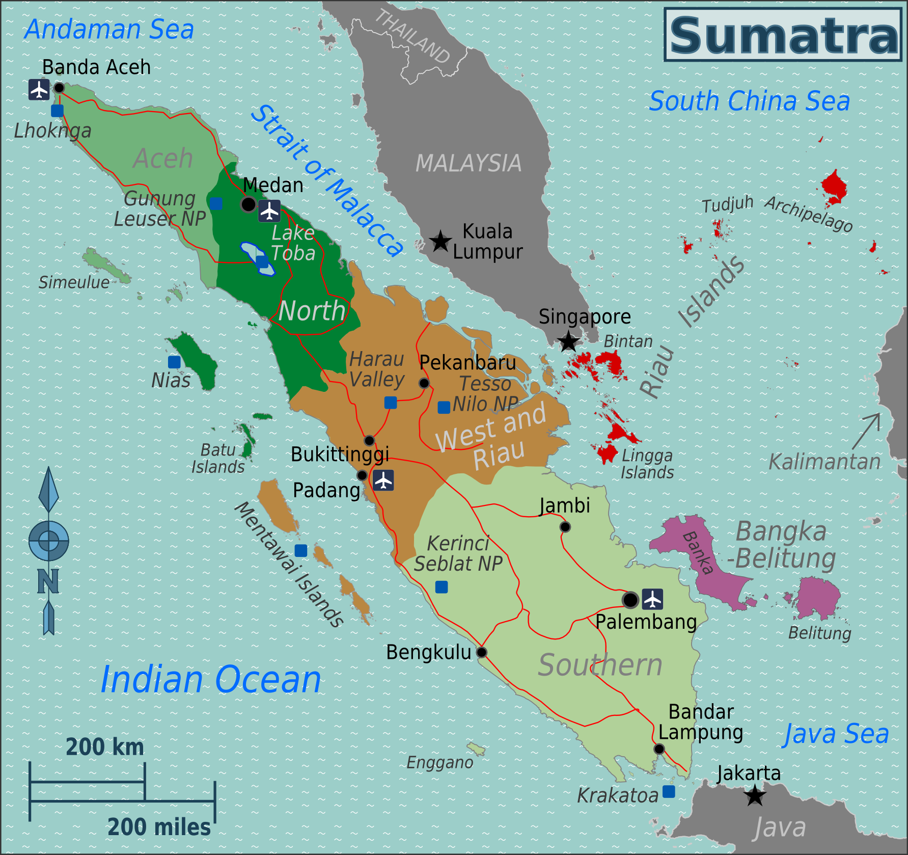
English: Map of Sumatra with regions colour-coded. SVG, Sumatra
|
| Tanggal | |
| Sumber | :image:Sumatra regions map.svg |
| Pembuat | User:(WT-shared) Burmesedays, OpenStreetMap |
Lisensi
Berkas on ipartandoan sian on Creative Commons Attribution-Share Alike 3.0 Unported partadoan.
- Anda diizinkan:
- untuk berbagi – untuk menyalin, mendistribusikan dan memindahkan karya ini
- untuk menggubah – untuk mengadaptasi karya ini
- Berdasarkan ketentuan berikut:
- atribusi – Anda harus mencantumkan atribusi yang sesuai, memberikan pranala ke lisensi, dan memberi tahu bila ada perubahan. Anda dapat melakukannya melalui cara yang Anda inginkan, namun tidak menyatakan bahwa pemberi lisensi mendukung Anda atau penggunaan Anda.
- berbagi serupa – Apabila Anda menggubah, mengubah, atau membuat turunan dari materi ini, Anda harus menyebarluaskan kontribusi Anda di bawah lisensi yang sama seperti lisensi pada materi asli.
Log pengunggahan asli
| This file was imported from Wikivoyage WTS. |
Halaman deskripsi aslinya ada di sini. Semua nama pengguna berikut merujuk pada wts.wikivoyage-old.
- 2011-08-24 14:00 (WT-shared) Burmesedays[dead link] 1783×1678 (765053 bytes) {{Imagecredit|credit=[[User:Burmesedays]], [http://openstreetmap.org OpenStreetMap]|captureDate=August 2011|location=Sumatra|source=[[:imag (Import from wikitravel.org/shared)
- 2011-08-24 14:48 (WT-shared) Burmesedays[dead link] 2000×1882 (1008740 bytes) +roads, airport and scale (Import from wikitravel.org/shared)
- 2011-08-24 14:52 (WT-shared) Burmesedays[dead link] 1783×1678 (859300 bytes) (Import from wikitravel.org/shared)
Riwayat berkas
Klik pada tanggal/waktu untuk melihat berkas ini pada saat tersebut.
| Tanggal/Waktu | Miniatur | Dimensi | Pengguna | Komentar | |
|---|---|---|---|---|---|
| terkini | 19 Desember 2012 01.08 | | 1.783 × 1.678 (839 KB) | OgreBot | (BOT): Reverting to most recent version before archival |
| 19 Desember 2012 01.08 |  | 2.000 × 1.882 (985 KB) | OgreBot | (BOT): Uploading old version of file from wts.wikivoyage; originally uploaded on 2011-08-24 14:48:15 by (WT-shared) Burmesedays | |
| 19 Desember 2012 01.07 |  | 1.783 × 1.678 (747 KB) | OgreBot | (BOT): Uploading old version of file from wts.wikivoyage; originally uploaded on 2011-08-24 14:00:06 by (WT-shared) Burmesedays | |
| 18 November 2012 02.56 |  | 1.783 × 1.678 (839 KB) | MGA73bot2 | {{BotMoveToCommons|wts.oldwikivoyage|year={{subst:CURRENTYEAR}}|month={{subst:CURRENTMONTHNAME}}|day={{subst:CURRENTDAY}}}} == {{int:filedesc}} == {{Information |description=Map of Sumatra with regions colour-coded. SVG, Sumatra * Map of: Sumatra¤ |da... |
Penggunaan berkas
Halaman berikut menggunakan berkas ini:
Penggunaan berkas global
Wiki lain berikut menggunakan berkas ini:
- Penggunaan pada en.wikibooks.org
- Penggunaan pada en.wikivoyage.org
- Penggunaan pada nia.wikipedia.org